
Proposed new Civic Office Headquarters
Monaghan County Council recently submitted a Part VIII Planning Application for new Civic Offices located at the Rooskey Lands in Monaghan Town. The purpose of the development is to consolidate and improve Monaghan County Council’s civic facilities, office accommodation and improve our customer service offering. The project will ultimately lead to service efficiency improvements by lowering operational costs; by eliminating current office rental arrangements and reducing the Local Authority’s energy demand. The new office accommodation will have a gross floor area of 5,601m2, distributed over three tiered floors, incorporating an entrance foyer, office spaces, meeting rooms, a staff canteen, council chamber, customer service desks, welfare facilities and internal landscaped courtyards. The planning application also provides for a new Rooskey Lands access road, improved pedestrian and cycle links, a car park and all associated site development works.
The proposed Civic Offices marks the first phase of an ambitious economic development and regeneration strategy for the Rooskey Lands and Dublin Street areas. The project is aligned with the provisions of the Rooskey Master Plan and the approved Variations of the County Monaghan Development Plan. The Masterplan and approved Variations seek to regenerate an area in urban decline, generate employment and contribute to the creation of a new urban quarter, whilst integrating successfully with the established built-up area of the town and providing a consolidated home for Local Authority service provision. The project will also act as a catalyst for the regeneration of Dublin Street and its back lands, making Monaghan a better place to work, live and visit.
Some of the Key features of the Project are identified in Image 1 and described briefly below.
Pedestrian Access to Diamond Centre/Square
The project Architects Henry J Lyons, propose a number of pedestrian and cycle paths through the site linking directly to the town centre through the Diamond Car Park, Dublin Street and Old Cross Square areas.
Active Travel Access Road to Roosky Lands
The town centre site encourages sustainable modes of travel. The proposed new access to the Rooskey Lands and Civic Offices provides dedicated cycle lanes and pedestrian footpaths which link to the existing Ulster Canal Greenway, St Davnet’s Healthcare and Monaghan Harps GAA Club, promoting active modes of travel for locals and visitors. The new Rooskey Lands access road will also provide the vehicular route for people arriving to avail of Monaghan County Council services, as well as providing access to the remaining Roosky Lands for future mixed use development.
Farney Place
The Public Plaza marks the entrance to the Civic Offices and provides visitor and accessible parking spaces. Farney Place is also one of the key pedestrian spaces; connecting the proposed Dublin Street North Regeneration Plan and the future development of the Rooskey Lands.
Infirmary Hill Walk
The existing pedestrian path beside the Old Infirmary and leading to St Davnet’s HSE facility is proposed to be widened and upgraded from Old Cross Square, it will intersect with the proposed pedestrian and cycle facility on St. Davnet’s Row and on to Farney Place.
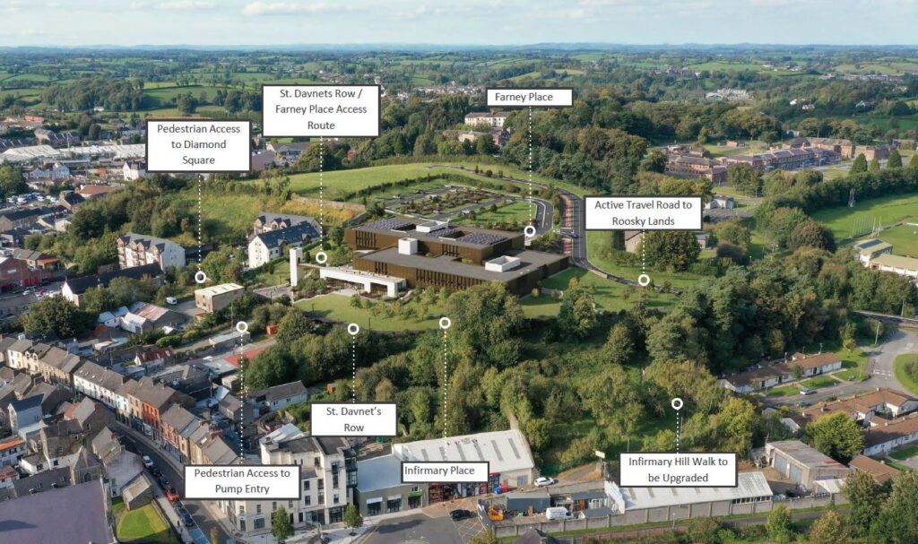
Image 1. Bird’s Eye View from Old Cross Square – The proposed new Civic Offices for Monaghan County Council will provide a modern, inclusive building which engages with the town and serves its population through an enhanced public realm design and high-quality architecture.
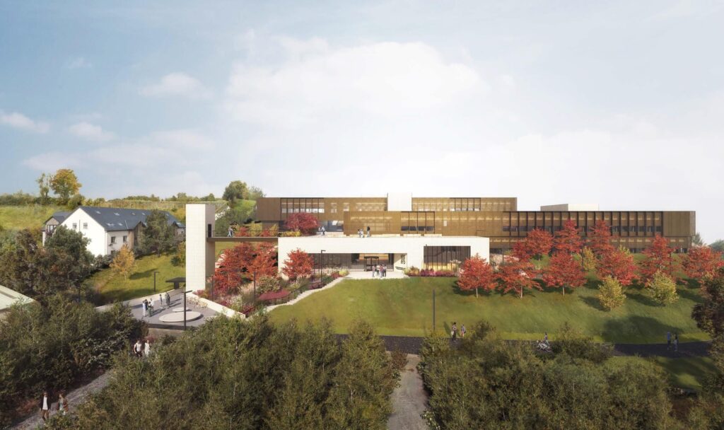
Image 2. Bird’s Eye View from Dublin Street North – The scale and massing of the Proposed Civic Offices has been carefully considered to provide an appropriate and sympathetic interface between the proposed site and existing properties of Dublin Street and the Apartments of The Diamond Centre.
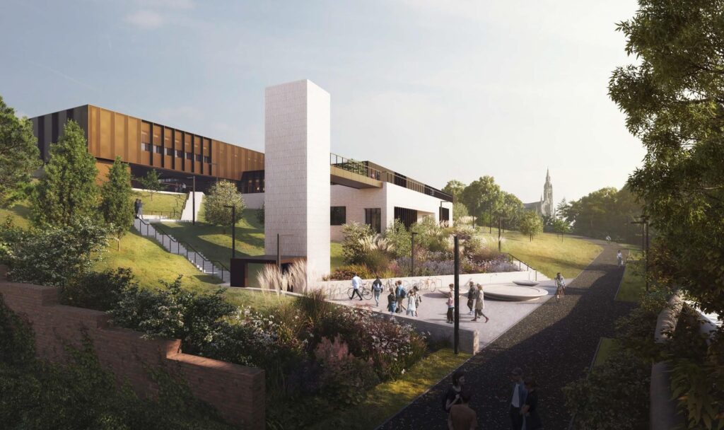
Image 3. Approach from Diamond Square – Pedestrian movement, cycling and the creation of public spaces are defining principals of the site strategy, improving the connections with the existing network of streets and the future connections proposed in the Dublin Street North masterplan.
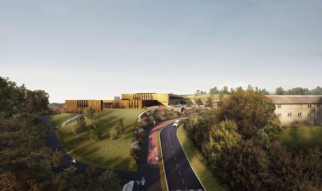
Image 4. Approach from proposed new Roosky Access Road – The consideration of scale started at the site edges and perimeters with the concept of three volumes being placed centrally on the site. These three volumes are interlinked and overlap each other to sit comfortably on the site, framed by a series of landscaped spaces.
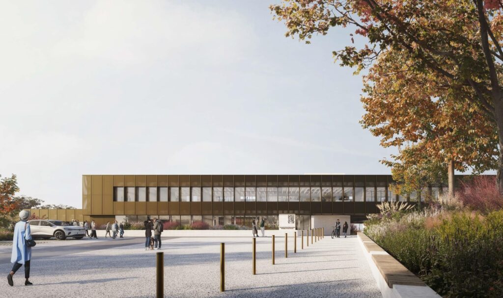
Image 5. Approach from Farney Place – Farney Place is one of the key pedestrian spaces. The public plaza is designed to be flexible to allow for community events while also catering for the daily needs of customers and visitors.