N2 Clontibret to Border Road Scheme – ‘Initial’ design published
Over the past number of years, Monaghan County Council has been working in association with Transport Infrastructure Ireland, (TII) to develop a scheme to upgrade a 28km section of the N2/A5 Dublin-Derry Road. The proposed project is in County Monaghan and is called the N2 Clontibret to Border Road Scheme.
The development of this project is supported by local, regional and national policy, and it also forms part of the EU’s Trans-European Transport Network. When the project is complete, it will bring a wide range of benefits, including supporting balanced regional development by improving accessibility and connectivity to the border and north west regions.
The project will bypass Monaghan Town, Emyvale village and the settlement of Corracrin, removing traffic congestion, improving safety and enhancing the urban environment for all road users.
The project will create opportunities for new and upgraded footpaths and cycleways along the length of the scheme, providing safe infrastructure for more people to walk and cycle to work, and improving connections to amenities like the Ulster Canal Greenway and other local facilities. This element of the project will also support the move to lower carbon emissions, assisting us to meet climate action targets.
The new road will support the local and regional economy, providing a more reliable and efficient road transport network. It will improve journey times and journey time reliability to ports, airports and markets, making the border and northwest region a more attractive area for investment and job creation. An improved road network to the northwest also has the capacity to strengthen tourism and visitor numbers to Monaghan, the Border and the northwest region.
Robert Burns, Chief Executive of Monaghan County Council, noted how important this project is to County Monaghan and the northwest region; ‘The N2 Clontibret to Border Road Scheme is an important project to boost safety, reduce travel times, enhance regional connectivity, and support economic and environmental improvements. Monaghan County Council is also engaging with other Local Authorities north and south of the border to ensure this project is just one of a series of proposed road improvements, that together will provide a cohesive and integrated upgrade of the northwest corridor that can efficiently and safely cater for traffic into the future’.
The project currently has funding from the EU’s ‘Connecting Europe Facility’ Fund, with match funding provided by the Department of Transport and administered by TII. Jacobs Consulting Engineers are the designer appointed to progress the planning and design of the project.
A Type 2 divided dual carriageway cross section is proposed. The new road will have two lanes in each direction, with a narrow central reserve to provide safe overtaking opportunities. The number and location of new junctions will be strategically planned, considering the needs of all road users.
The N2 Project Team has substantially completed the necessary surveys/investigations to prepare an ‘initial’ design of the proposed road. In March, the project team contacted approximately 260 directly affected landowners, inviting them to meet with members of the project team to discuss the potential impact of the scheme on their lands. Landowners received maps of their land holding, with details of how much land or would be acquired for the scheme. Paul Gibbons, Cathaoirleach of Monaghan County Council noted ‘On behalf of the project team and Monaghan County Council, I want to sincerely thank all landowners who have attended meetings for their engagement – in many cases landowners were told that they will be significantly impacted by the proposed scheme, and it is a difficult time for many people’.
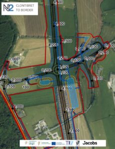
After 3 weeks of landowner meetings, details of the initial road design are now being made available to the wider community and stakeholders along the route of the proposed road. The design is available via an interactive map on the project website. The design shows the ‘initial design’, which will be subject to change following feedback from landowners and stakeholders.
The interactive map shows the route of the proposed N2, the locations of the proposed interchanges and junctions, and the route of proposed sideroads and access roads along the N2. It shows drainage attenuation ponds, and the extent of propose earthwork cuttings and embankments. This will provide the wider community the opportunity to view the impacts of the project on the local road network. The answers to Frequently Asked Questions can also be seen on the project website.
Feedback can be submitted to the N2 Project Team by email ClontibretBorder@N2MonaghanLouth.ie or via the N2 Project Phoneline 087 340 3786.
Over the coming months the N2 Project Team will consider feedback received from landowners and other stakeholders, and will then make changes and updates to the ‘initial’ design before a design is finalised. An Environmental Impact Assessment Report and Compulsory Purchase Order documentation will then be prepared. Subject to funding and approvals, an application would then be submitted to An Bord Pleanála as part of the planning approval process.
Large infrastructural projects of this scale take time to plan and deliver. Subject to approvals and available funding, the project is likely to take another 5-6 years of planning and design, and construction is not due to commence until after 2030.